


Reinnesfjellet – Spectacular Granite Slab Biking in Skjomen
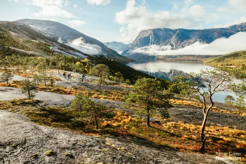
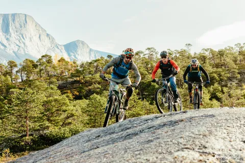
The route begins at the parking area along the service road in Sørdalen, deep within Skjomdalen. From here, follow the trail up to the mountain plateau between Boazovarri and Reinnesfjellet. Once at the top, you'll encounter vast, open expanses of granite slabs ideal for playful and technical riding.
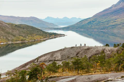
Along the way, enjoy spectacular views over Skjomenfjorden and the impressive Frostisen glacier on your left. The highest point of the ride reaches 804 meters above sea level, though most riding stays around 700 meters. You'll also find several small natural pools of sun-warmed meltwater—perfect for refreshing breaks or capturing iconic photos. Keep to the right as you approach the last kilometers towards the peak of Reinnesfjellet to avoid a dead-end at a steep slab.
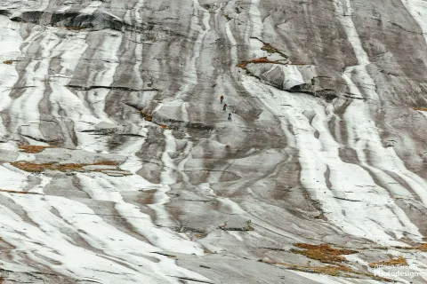
The descent from Reinnesfjellet is a thrilling, rare downhill ride over solid granite slabs mixed with sections of dirt trails, ending with a short paved stretch towards Skjomen Golfpark. Note that the descent demands solid bike-handling skills and experience on steep terrain. Granite slabs can become extremely slippery when wet, so only attempt the ride in dry conditions.
When you tip over the edge toward the fjord, you’ll quickly understand why Kjetil Jansrud from the Norwegian reality TV show "71° Nord" was so impressed:
"Full-suspension e-bike across Reinnesfjellet on what must be one of the most spectacular mountain bike routes in the world? Yes, please! What a stage, what an experience. Riding a mountain of granite slabs is one of the most epic things I've done!"
Enjoy your adventure on two wheels between fjords and mountains!
Key Information
- Trail type: Granite slab and terrain biking
- Level: Challenging (Level 5)
- Distance: Approx. 20 km
- Elevation: Approx. 680 m ascent/descent
- Duration: 4–6 hours
- Season: Summer to early autumn
- Surface: Solid granite slabs, dirt trails, asphalt
- Starting Point: Parking area along the service road in Sørdalen, deep in Skjomdalen
- Endpoint: Skjomen Golfpark
- Suitable for: Experienced riders with solid technical skills
Maps and Route Information
- Trailguide: Reinnesfjellet on Trailguide
- GPX-file: Available for download here. Maps provide general route direction and start points but are not suitable for precise navigation. Always make your own assessments based on terrain and conditions encountered.
Accessibility and Logistics
- Directions: Drive south on E6 from Narvik towards Skjomen. Turn left just before the Skjom bridge and follow road FV761 along Skjomenfjorden. Parking near Narvik Golf Club is practical if planning to shuttle. Continue on Skjomdalveien until it sharply turns right and climbs steeply up the mountainside in Sørdalen. At the top of the climb, the parking area is on your right.
- Parking: Free parking at the service road: https://maps.app.goo.gl/Y2oYVB3QzAq2dNBX8
- Bike Rentals: Day Out Narvik offers rentals of full-suspension electric mountain bikes
- Food and Drink: Golfsvingen Kro & Motell at Skjomen Golfpark offers dining and accommodation.
Tips and Recommendations
- Best Time of Day: Late morning to early afternoon. Experience midnight sun in the Narvik region from May 24 to mid-July.
- Alternative Route: Push your bike up to the cairn on Reinneset for an easier descent.
- Photographic Highlights: Exceptional views of Skjomenfjorden and Frostisen glacier during the descent, plus small meltwater pools perfect for spectacular "infinity pool" photos.
- Local Cycling Events: Narvik Bike Festival, September 4–7, 2025
Equipment and Preparation
- Essentials: Water, tools, map/GPS, extra clothing
- Service Points: None nearby; closest bike service at SportCentret Narvik
Safety and Responsibility
You ride challenging terrain at your own risk. Assess your skills, equipment, and weather conditions carefully. Always wear a helmet and respect nature and other trail users.